

Abstract
Background and Issues
- At present there is significant closure of facilities as the population reduces, and the formation of hubs in which facilities, etc., are concentrated is in progress in accordance with municipalities’ plans
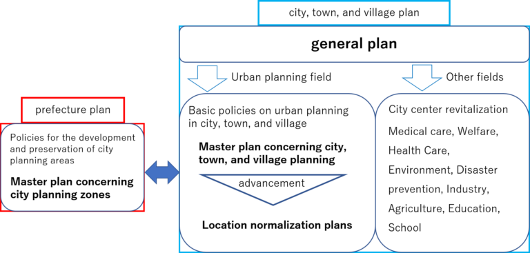
- In the urban planning zones, hub planning is being considered in the urban planning master plans or location optimization plans, etc. (Fig. 1), and in areas other than urban planning zones the aim is formation of “small hubs”
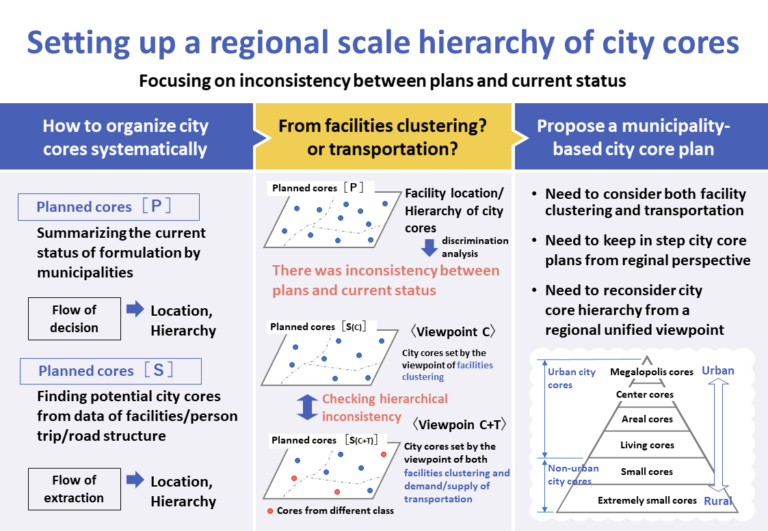
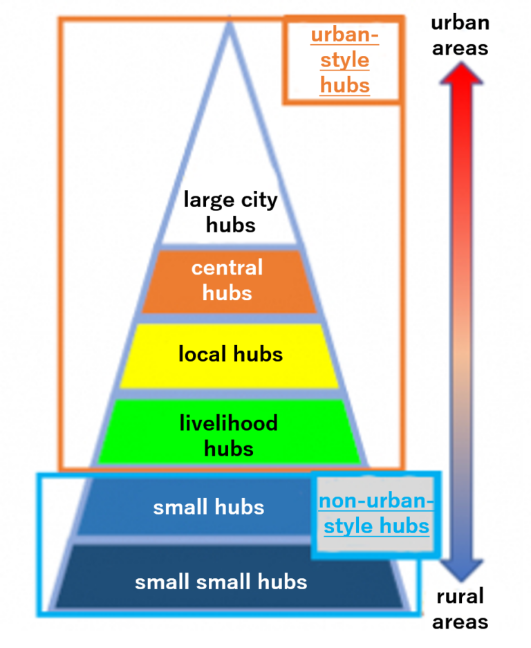
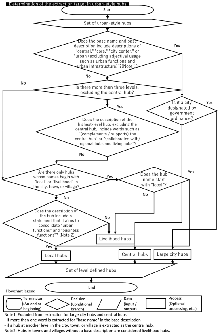
- Hubs have a hierarchy (6 levels from “large city hubs” to “small small hubs”) (Fig. 2), but urban-style hubs and small hubs are planned separately
- As further reduction in facilities continues in the future, it is considered that cooperation between hubs over a wide area that extends beyond municipalities will become necessary. However, no wide area or unified hub hierarchy has been developed, either between urban areas and hilly and mountainous areas, or between municipalities. This could lead to an extremely inefficient area structure
In this research, the hub plans for the municipalities of Gunma Prefecture were studied by organizing and comparing the hub locations and hub hierarchy from various aspects using a specially constructed hub extraction algorithm and decision analysis. At the same time a hub extraction method and hierarchy determination method necessary for hub planning from a wide area and unified perspective have been proposed. Also, a deviation between hub planning and the actual situation has been identified, which suggests the viewpoint necessary when reviewing hubs in the future.
Analysis
Overview of the Analysis
| Analysis Target Area | All Gunma Prefecture |
| Data | Future city structure map for municipality hub planning Facility data Traffic behavior, road data, etc. |
| Analysis Method | Analysis using hub extraction algorithm Decision analysis |
Determination of the location and hierarchy of planned hubs [P]
- The current status of formulation of hub plans was organized, and the positions and hierarchy of the planned hubs [P] were determined (Figs. 3 and 4)
Determination of potential hubs (planned hubs [S])
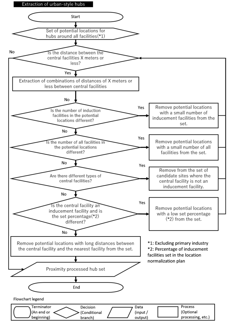
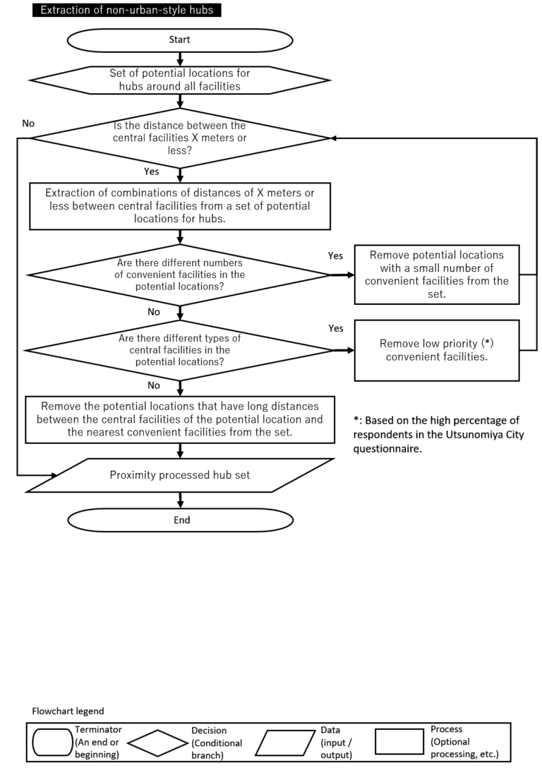
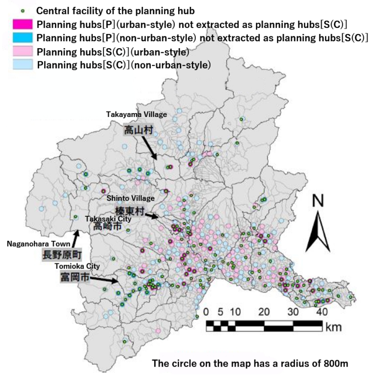
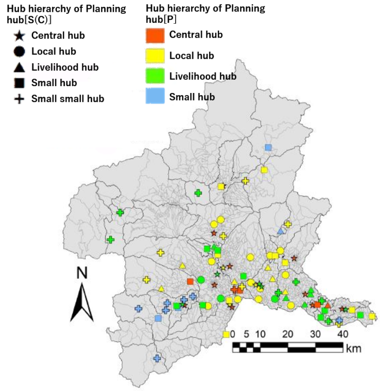
The planned hubs [S(C)] are identified from the point of view of facility integration (point of view C) required in traditional hub planning, and the hierarchy of the planned hubs [S(C)] is determined (Figs. 5 and 6)
For planned hubs [S(C)], the method of identification of hubs adopted differed between urban-style hubs and non-urban-style hubs (Figs. 5 and 6)
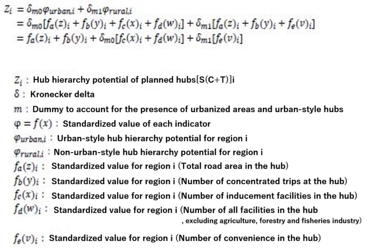
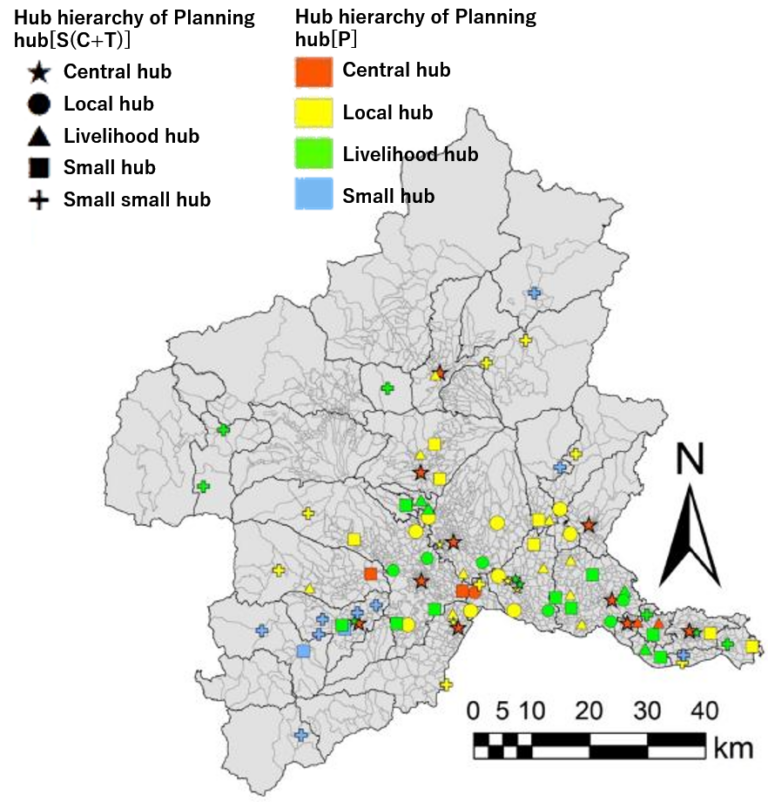
Postulation of planned hubs [S(C+T)]
- Not only point of view C but also point of view C+T, which takes into consideration the supply and demand of traffic is postulated, based on the “compact + network policy” in recent years
- At the same positions as planned hubs [S(C)], the hub hierarchies of point of view C and point of view C+T were compared to identify any deviation
- The specific hub hierarchy potential equation is as follows
Further analysis based on information regarding these hubs
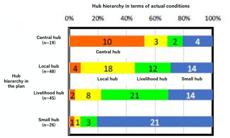
- When decision analysis is performed regarding the facility locations within planned hubs [P] and their hub hierarchies, even in the case of urban-style hubs in the plan, there are small-level hubs that are two or more times greater in number than small hubs in the planned hubs [P]. There are also many hubs that are smaller than the small hub level in the upper hierarchy, etc. Therefore it is clear that there is a deviation between the plan and the reality in the case of hub hierarchy (Fig. 7)
- As a result of comparison of planned hubs [S(C)] and planned hubs [P], it was found that there were many planned hubs [P] that were not identified as planned hubs [S(C)] (Fig. 8)
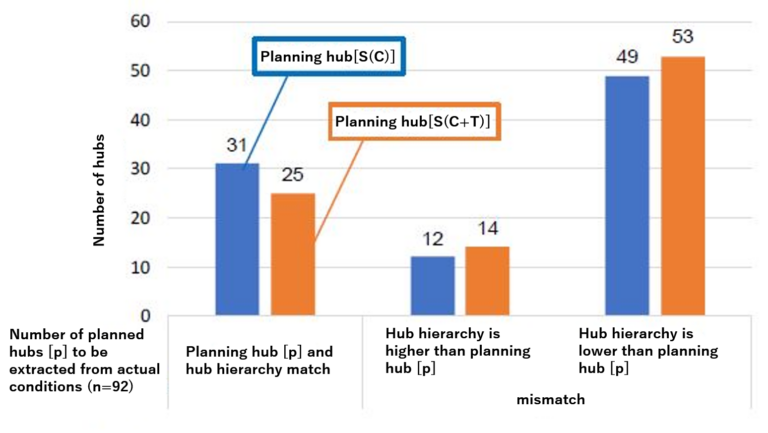
- In planned hubs [S(C)] and planned hubs [P] where the locations match, there were large differences in the hub hierarchy (Fig. 9)
- From these, it is clear that differences have occurred between planned hubs [S] and planned hubs [P] in terms of hub hierarchy and their locations
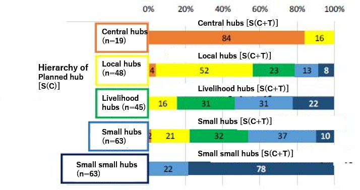
- Focusing on the locations where a difference occurs between the planned hubs [P] and the planned hubs [S], by comparing the hub hierarchies in planned hubs [S] from the point of view C and the point of view C+T, it was found that there is a high possibility that hub hierarchies of the existing planned hubs [P] have been determined by facility integration (Figs. 10 and 11)
- Comparing the hub hierarchies for all the planned hubs [S] from the point of view C and the point of view C+T, in the hub hierarchies from the point of view C the number of concentrated trips for local hubs, livelihood hubs, and small hubs are about the same, and hence it is considered that point of view T is absent from current hub hierarchy setting (Fig. 12)
Recommendations
- A method of determining the “planned hubs [P] locations and hierarchies”, “planned hubs [S(C)] locations and hierarchies”, and “hub hierarchy from the point of view C+T at the same locations as planned hubs [S(C)]” has been proposed
- The following are suggested for hub planning municipalities
– The necessity of review of hub hierarchies from a wide area and integrated point of view
– The necessity of taking into account both the facility integration and the traffic points of view
– The importance of keeping hub planning in step by multiple municipalities over a wide area unifying their timing of change and the situations to be addressed in their plans, by municipalities arriving at a consensus of intentions, and by cooperation with wide area administration such as prefectures, etc.
References
Ministry of Land, Infrastructure, Transport and Tourism HP: Guidance on Preparation of Location Optimization Plans, http://www.mlit.go.jp/toshi/city_plan/toshi_ city_
plan_tk_000035.html (last accessed May 2019)
Prime Minister’s Office of Japan homepage: Town / People / Work Creation Headquarters. Forming Small Hubs, https://www.kantei.go.jp/jp/ singi/sousei/about/chiisanakyoten/ (last accessed May 2019)
Yuki Yamane, Eiji Morimoto, Mamoru Taniguchi (2017): Paradox Brought From Various Meanings of “Compact Villages” and “Compact Plus Network” Policy, Journal of Japan Society of Civil Engineers, Series D3, Vol. 73,No. 5, pp. I_389-I_398.
Yuki Yamane, Mamoru Taniguchi: Choosing “Compact Villages” Objectively to Realize Sustainable Life in Rural Areas Using “Compact Village Potential” Considering “Hard” and “Soft”, Journal of Rural Planning Association, Vol. 36, pp. 304-310, 2017.
Ministry of Land, Infrastructure, Transport and Tourism HP: “National Land Grand Design 2050 – Promotion of Cooperative-style National Land Formation to Achieve Complimentary Objectives”,http://www.mlit.go.jp/kokudoseisaku/kokudoseisaku_tk3_000043.html (last accessed May 2019)